1. Salar de Uyuni is the world's largest salt flat at 4,086 square miles.
2. Salar de Uyuni is part of the Altiplano of Bolivia in South America. The Altiplano is a high plateau, which was formed during uplift of the Andes mountains. Elevation on the Salt Flat is 12,000 feet.
3. The Salar contains large amounts of sodium, potassium, lithium and magnesium as well as borax. Of those, lithium is arguably most important as it is a vital component of many electric batteries. Bolivia holds about 43% of the world's lithium reserves and most of those are located in the Salar de Uyuni.
4. There is currently no mining plant at the site, and the Bolivian government does not want to allow exploitation by foreign corporations. Instead, it intends to build its own pilot plant.
5. Salar de Uyuni is estimated to contain 10 billion tons of salt, of which less than 25,000 tons is extracted annually.
Where we were, the salt is mined by individuals who have claimed an area about 20' x 60'. They use a mattock to break up the salt and dig down about 4-5 inches, then they scoop it up with a shovel into a cone-shaped pile. After it has dried, trucks come and pick it up and it is loaded on the trucks by hand. The areas that have been dug up will fill up again and level out; we're not sure how that process works.
Okay, that's probably enough to let you see why this area - though desolate in the extreme and very sparsely populated - is very important to the country of Bolivia. Now here are about 50 of the 800 pictures we took. There are many more things I could show you, but I really don't think you want to see that many pictures at one time so it will have to wait until we come home. (Incidentally, I think if you double-click on the pictures they will come up full-size so you can see the details therein.)
Monday - August 26
We flew from Cochabamba to La Paz, where we had a long layover (pictures of those activities another day) and then flew to Uyuni, the town nearest the Salar. We stayed Monday night at the Cristal Samaña hotel, which is made of salt (with a cement foundation). From the outside, you can't tell it's built of salt, but inside you surely can. The floor is covered with salt (which they change about every 3 months); the walls are decorated with salt carvings; the headboards of the beds are salt, and so on. This was our first cold night, but not the worst by any means. The hotel is being remodeled, so the heaters in the rooms didn't work. However, the management gave each room a small electric space heater which helped a little and best of all, they gave us each a big hot water bottle at bedtime! The worst part was having no hot water in the morning because someone had forgotten to turn on "something". I took my first (and last, believe me) cold shower so I could wash my hair. Br-r-r-r-r!
Here's a broad view of the hotel. It was cold, clear and windy - about 50 degrees, I would guess.

Farron standing by one of the many salt carvings, this one outside our room.

One of the wall carvings near the entrance (more light by the front door, hence the different look.)
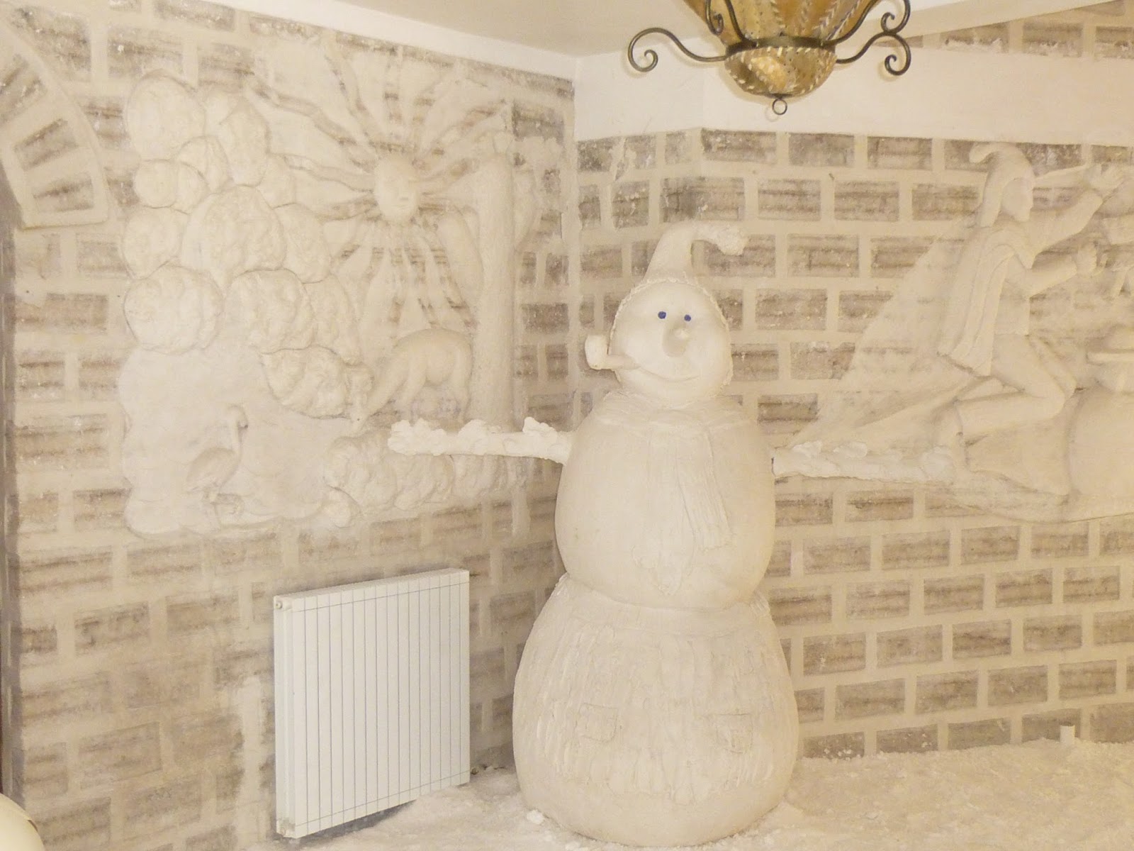
Me in our bedroom - our salt headboard was frogs, of all things! (We had a small frog-patterned rug to match.) Other rooms had snakes, flamingos, llamas, or ostriches above the beds. They are beautifully done. The beds also are made of salt blocks (the mortar between the blocks is a salt-and-water mixture.)

Lastly, the fireplace outside our room. The young man who was our liaison built the fire and kept it going for 2 or 3 hours so we could sit near it and be warm. It was WONDERFUL (though I have no idea where they get the wood - which looked like pieces of tree branches. There is not a tree in sight for miles.)

Tuesday - August 27
The tour company arrived to load us into three Toyota Landcruisers. Our luggage (along with all the food for the trip AND the gasoline) was piled on top. We could see nothing BUT salt for miles in all directions.

Our first stop was near where they were "harvesting" salt.

After driving for several hours, we arrived at Fish Island. (The Salar was once a huge sea, so this really was an "island".) Fish Island is covered with more than 6,000 cactus, which grow about a centimeter a year. Here's Farron near one of the larger ones (probably about 900 years old.)

We climbed to the top of Fish Island - no mean feat at this altitude - and this is one of the views from the top - endless salt in all directions (and no roads - PLUS compasses don't work because of the minerals in the region - so people who travel here must have a guide who knows the area by heart and can drive without any signs, roads, or directions - just what's in his head.)

Here is our group, gathered at the top. You can see that we had warmed up (it was lunch time). The sun is so close at this altitude that you don't need a heavy jacket while the sun is shining and IF the wind is not blowing.
(Front row, kneeling: President Dan Dyer of the Cochabamba Bolivia Mission and his wife Christy in the red shirt; Sister Lorna Hoopes, full-time missionary serving here with her husband for 6 months. Back row L/R: Diana Crayk, temple missionary; Elder Hoopes; Lynn Crayk (Diana's husband); Farron and I; Lee Crayk (temple president) and his wife Connie; and at the very right, Dawn and Eldon Hurst, also temple missionaries.)

At the entrance of the park is a museum of sorts. In this room are various posters and displays that explain the traditional religion of the Aymara people, including the sacrifice of young llamas (white, without spot or blemish - just like the ancient Jewish traditions in the Old Testament. Isn't that interesting?) The llamas are blindfolded, you will notice. One of the posters on the wall shows what they do with the blood after the sacrifice. Yuck!

After lunch we drove for several hours, leaving the Salar and progressing upward on the altiplano to a little settlement called San Pedro de Quemez. The Ciudad de Piedra Lodge is a community project there as the sign explains. (Translated from Spanish: the building was constructed of 42,350 blocks of stone; the work was done over 18 months by 34 families; the water in the building is from a natural spring; solar energy is used to heat water for the building; the roofs were made in the ancient way from thatch.) This was funded by a foreign company which owns and operates the place for 15 years while the indigenous people are trained in tourism etc. At the end of the 15 years, the place will revert to the community.

A picture of the thatched roof.

It's great that the lodge is environmentally-correct (i.e., solar-heated) except that it means you can have a hot shower (if you're lucky) in the afternoon, but there will be no hot water in the mornings. A few of our group took showers as soon as we arrived, but the supply of hot water was limited and Farron, for one, got a tepid shower. I didn't even try. The rooms were supposed to be heated, but the heater wasn't working, so we had another cold night. Luckily I had listened to Dawn Hurst, who told us all to bring hot water bottles (the Hursts and we were the only ones who had them in our luggage and this lodge didn't supply any.) The lodge did have flannel sheets and good comforters on the beds, so although the room itself was freezing, we slept warm enough (in our sweats). Here's a picture of our bedroom.

That night they drove us down to the village to an unheated adobe hut where we had dinner (barely warm lasagna made from lunch's left-over lasagna). I don't know what the sauce was, but it didn't taste like anything I've ever eaten. I could only choke down a couple of bites and gave the rest to Farron. Luckily they had soup first (they always do) and I liked the soup, plus the hard bread to dip in it. Here's a picture of the village of San Pedro de Quemez at night (from our "hotel").

Wednesday - August 28
This was our longest and by far coldest day. We got up and out early but we had miles to cover, over very rough roads (or no roads, much of the time.) That's why we were in four-wheel-drive vehicles. We went over rocks that I thought surely would tear off the oil pan, but these vehicles ride a lot higher than I realized. Early in our trip this day, we entered the Eduardo Avaroa Reserva Nacional de Fauna Andina (the Eduardo Avaroa National Reserve of Andean Fauna) - a national park, in other words. Elevation in the park ranges from 13,800 to 17,700 feet - and that's not counting the height of the volcanic mountains.
We were surrounded by 49 volcanoes (almost all extinct) throughout the day and it was interesting to me that - because we were already so high - these volcanic mountains, some of which were almost 20,000 feet - didn't look very "tall" at all. Early in the drive, we came to an area of fossilized rocks called "The Stone Army". Here's a picture of me beside one of the "soldiers". They cover acres and acres of ground and the funny thing is that even though they are rock, they all lean to one side as do trees that have grown up in a windy area. I don't quite understand how that happened.

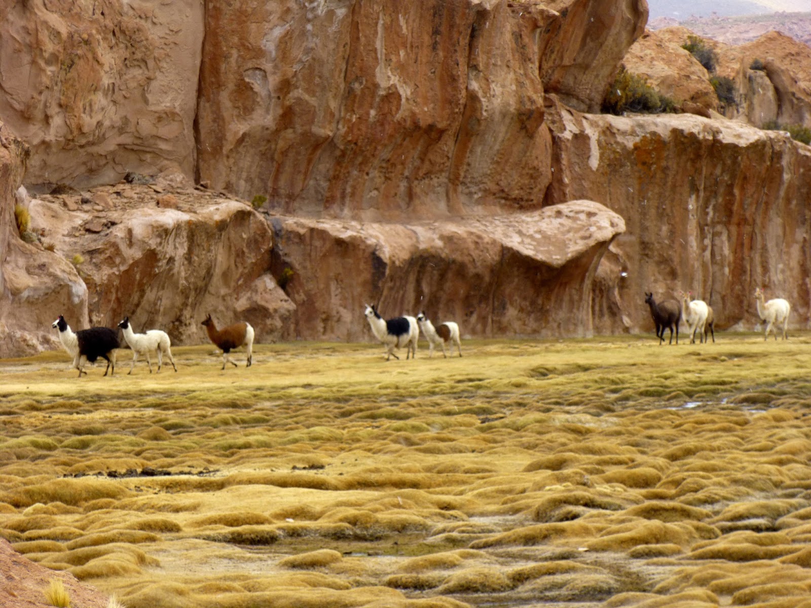
While we were driving we often saw vicuña like these. They seem to live in the most rocky, inhospitable parts of the altiplano - we literally could see nothing they could eat, yet they find some tiny plant on which to graze. They are relatives of the llama but can only be domesticated if raised from birth. The grown animals are always wild.

We stopped in this canyon in the Siloli Desert for lunch. (The lodgings where we stayed provided breakfast each morning - usually bread, jelly, cocoa or hot tea and maybe yogurt - while our lunch and dinner were provided by the tour company. We had the cook with us in one of the vehicles AND all the food for the trip.) Lidia was preparing our lunch while some of us climbed up to the hill. There was nothing to see but more desert and more hills, so we came back down.

The tour companies all stop in this sheltered canyon for lunch, I guess, so the viscacha (a native animal) have become somewhat used to tourists and will even approach the camp for handouts. President Dyer says that in many areas of Bolivia, this animal is hunted for food. They jump rather like a kangaroo but have a long tail like a raccoon (only not striped). From the side, the head looks like a kangaroo's but from the front, he looks like a rabbit. Weird!

After lunch, we walked a mile or so while the cook and drivers cleaned up and reloaded everything. Along the way we came to this icicle! (L/R, President Dyer, President Crayk, and Farron.) You can see we were in cold country. Elevation here was probably around 15,000 feet.

One of the famous sites in this national park is this "Stone Tree". It is a softer stone at the bottom than at the top, hence the constant wind has worn away the "trunk" much faster than the top of the "tree". This was one of the places that was supposed to have a public restroom (baño) - which it did, but the building was locked. And there were several other tour companies on the road so there were quite a few cars and quite a few people there. Very difficult to find a rock to hide behind, but most of us managed to do it out of necessity!

We passed many lagoons, one of which is called "Blue Lagoon", but I didn't include a picture here because you all have seen plenty of blue water. The lagoon below - Laguna Colorada (Red Lagoon) - really IS red. It is because of algae in the water. The blue and white behind us is ice; all the rest between us and the mountain (that looks like red dirt) is really red water. It's less than 33 inches deep so the flamingos can walk all the way across it.

All of these lagoons have flamingos in them. I always thought flamingos were a tropical bird, but here they are living above 14,000 feet in a very cold environment. There are three species - the James Flamingo, the Chilean Flamingo and the Andean Flamingo. The James Flamingo was thought to have become extinct in the early 1900's but explorers finally came into this area in 1957 and found thousands of flamingos in these colonies. Good news for bird-lovers.

We were told we might not be able to get into the Green Lagoon area because of snow the previous weekend, but we made it (with a little difficulty). It really is a beautiful green - this time because of arsenic and copper in the water. As you can imagine, the water is poisonous and this is the only lagoon we saw that didn't have flamingos. Behind it (on the left of the picture) is an extinct volcano (Licancabur) which has in its summit crater the world's highest lake (19,400 feet) and the lake doesn't freeze because of vents from the volcano that pour hot air (or lava?) into it. The lagoon is at 14,000 feet according to Wikipedia, though we all would have sworn (because it was SO COLD there) that we were much higher. The problem was that the sun wasn't shining and the wind was blowing - and we were freezing.

The place where we stayed that night is not even a lodge; it's called a refugio (refuge) and is there to provide shelter from snow and wind but not much else. This truly is wilderness area. There is no electricity, no cell phone service, no piped water, etc. We were simply at the top of the world and at the mercy, more or less, of the elements. This night was the coldest and highest night. There was one tiny wood stove (about 18" x 24") in the dining area, around which we took turns crowding, and no heat anywhere else in the building. I don't know what they burn for fuel - there are no trees in the area because it's far above the tree line. It looked like fossilized something-or-other that they were putting in the stove. I've been told they burn a plant called yereta, though I've seen that plant and how you could make anything to burn out of it, I don't know. Here's what it looks like. It feels like a rock (not like moss), but Sister Crayk got some kind of sap on her hand from it. Very strange.

As we were going to bed, the guide told us the drivers were going to get up and check at 2:00 am and if it was snowing, we would have to get up and get out right then or be trapped there for 3 or 4 days. Half of us were praying it would start to snow, just to get out sooner – the other half (me, for one) were praying it wouldn’t snow because I couldn’t think of anything worse than getting up, going out in the cold to drive 1½ hours, and then sitting in a cold car at the nearest point of habitation (some hot springs with a public baño) for another couple of hours until the sun came up and the place came to life. (And we couldn’t have run the engine to keep the car warm because there is no place out there to buy gas. They carried all the gas for the trip on top of the cars and there wasn’t any extra.)
 Unfortunately, I was so cold my brain was frozen I guess, because I didn't take ANY pictures of the refugio inside and only a sunset picture outside.
(My camera was almost dead anyway. There was one plug powered by a generator for the lights in the kitchen and one of our group had a power bar, so all of us charged our cameras and/or phones on that power bar during dinner.) Three of our couples had rooms with a double bed and their own baño (no running water and the toilet was flushed by pouring in water from a big barrel in the corner). The Crayks, being family, took a room with two 3/4-beds and shoved them together and slept fully clothed, four in a bed. We were in a room that had three 3/4-beds, so we shoved two together and put all the blankets in the room on that one bed. We slept in our sweats again and managed to not quite freeze. The public baño was down the hall about two doors (hence, an icy trip). And of course there was no electricity so no light. Fortunately we had a little flashlight in our luggage. The temperature in our rooms was 37 degrees at 7:00 pm and it
only got colder during the night. This was surely one of the longest nights in our life and we were happy to get up and get out in the morning!
Thursday - August 29
This was what the road looked like on the way out.

The first place we stopped after we got out of the snow was the hot springs I mentioned earlier. The little yellow building is a bath-house (or whatever you call it) for changing into and out of swimsuits, but - true to form - it was locked. Those who wanted to bathe had to change in the public baño about 100 yards away. Br-r-r-r! Three of our group (President Crayk, his brother, and Jack Hoopes) actually braved the cold - just "for the experience". I seem to remember our son Ryan saying he did something of this sort while on his mission in St. Petersburg, Russia. This is an "experience" I can do without.

President Crayk, his brother Lynn, and Jack Hoopes in the hot springs.

Next we visited an area of geysers. It reminded all of us of Yellowstone Park, except that you could walk right up to the edge of the geysers AND the bubbling mud pots. There were small holes here and there where you could hear the mud boiling underneath the ground - kind of scary! We were all very careful to stay back from the edges. The guide told us one foreigner had fallen in when the ground gave way and of course it killed her!

After the geysers, we visited the Red Lagoon again. This time we were on the south side of it. The sun came out briefly and we actually felt fairly unfrozen for a little while.

I finally got a shot of a flamingo with its wings spread so you can see the black underwing. Isn't it beautiful?

Next we had a rare treat - neither our guide nor two of our drivers had ever seen this! Christian, one of the drivers, was raised near a lagoon called Laguna Natal and used to swim in it as a child. We left the usual tourist route and drove down a winding canyon so narrow the cars could barely get between the rocks (or over the rocks in the trail), then came out at this little hidden valley.

It is bounded on three sides by these high stone cliffs (which are surprisingly climbable for people but not for animals) and at one end of the valley - we hiked about a half-mile to get to it - is the lagoon.

These are llamas walking down the valley - notice how small they are compared to the cliffs. Farron said it made him think of Louis L'Amour novels - the hidden valley, the good grazing, the ample water supply. It's easy to see why anyone would settle there.
However, we had to leave. A storm was brewing (it snowed on us briefly) and we had to get down off the high plateau. Shortly after we left Laguna Natal, we saw a couple of wild ostriches - though actually they aren't ostriches at all but rheas (suri, in Quechua). They are found only in South America (in the southern half of the continent). There are two "sizes" and it's the lesser Rhea that lives in Bolivia at elevations up to 14,800 feet.

Here's a shot of a herd of llamas we passed on our way to lower ground.


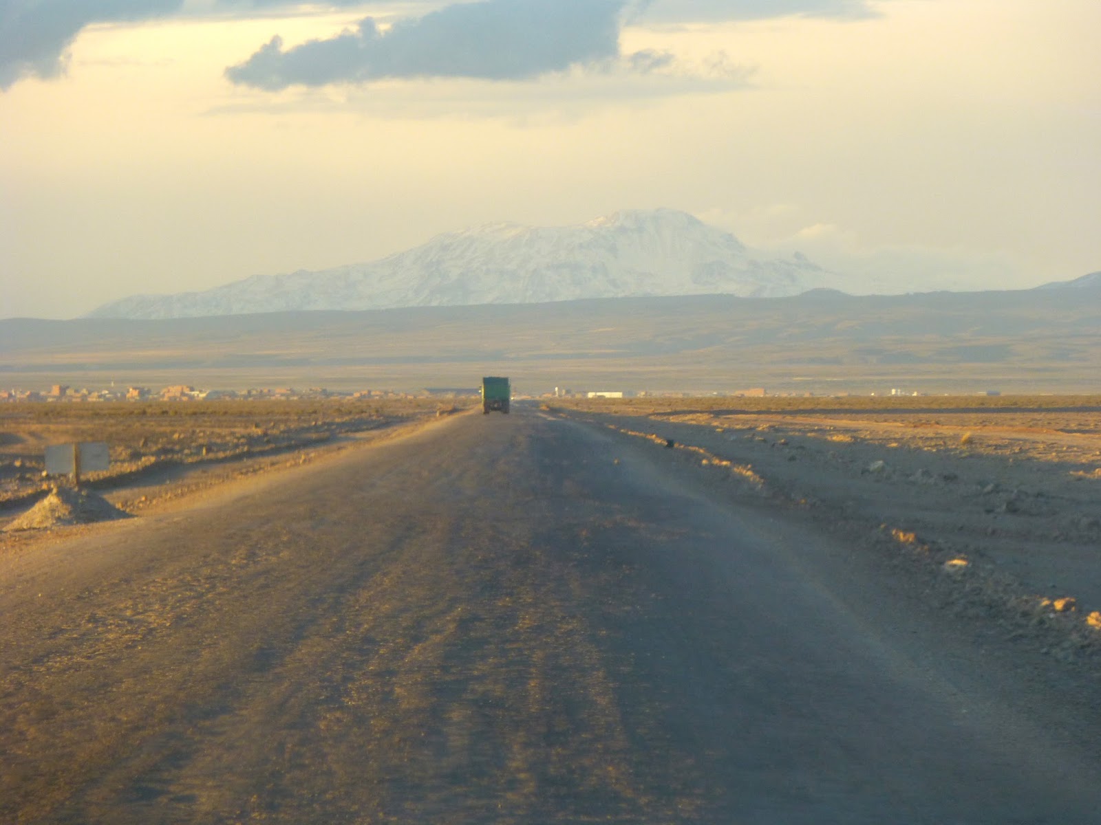
By this time it was 5:00 in the afternoon, cloudy, windy and COLD so we made no more stops but headed for Uyuni just as fast as we could. We had gone without heat, hot water and showers for three days and all we could think of was getting to the hotel and getting warm again. Here's our first sight of Uyuni - and notice the high mountain in the background. We are back "down" at 12,000 feet - that mountain is probably 20,000.
Our hotel in Uyuni was called Los Jardines de Uyuni - and after our three days in the wilderness, it felt like a Hilton. Here is a picture of the reception area.

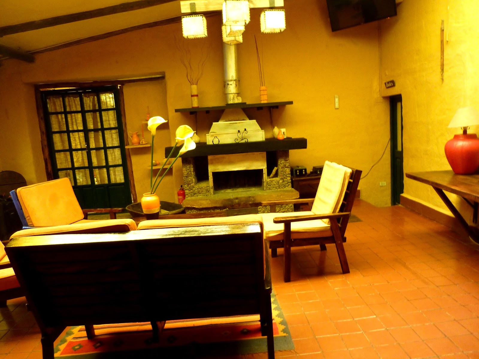
This is one of the lounges - there were several. (We really liked this hotel - it has lots of places for people to sit and talk or use their I-pads - the staff were super-friendly, helpful and kind - and best of all, there were not only hot showers but also an electric blanket on every bed!) They also have genuine antiques here and there around the place - really interesting! Those pictures are for another time, alas.
This is our bedroom.

We all decided we wanted to go eat - grubby and gritty (from dust) and tired as we were - because once we got clean and warm, we didn't want to go out into the cold again. So as soon as we checked in, we walked about five blocks to the Lithium Club which served us surprisingly-good thin-crust pizza. (And they brought two space heaters over to our area just to warm us up.) We were very happy to be back in Uyuni.
Friday - August 30
We all slept in, then enjoyed the continental breakfast provided by the hotel. We had to wait until 2:00 for the daily plane to La Paz, so about 10:30 we all went out and walked around downtown Uyuni. The week before - when President and Sister Dyer and the Hoopes were there for a district conference - it was snowing and blowing and utterly a miserable place to be. But we were blessed this day with bright sunshine and only a light breeze, so we had a lovely time. Uyuni has a lot of train heritage (including a "train cemetery" of sorts on the edge of town), so we appreciated this antique steam engine which is part of the downtown scene.

I'm not sure what this iron lady is supposed to signify but I thought you'd like to see her. (Her fingers remind me of Edward Scissorhands - what do you think?)

This is the central plaza of Uyuni - looking west toward the main street.

And this is the clock tower that stands at the center of town - very pretty.

About noon, we went to the Sal Negra (Black Salt) restaurant for lunch. It was crowded and the service was really slow (though the people were very nice). The food was good. We finished about 1:45 and needed to be at the airport by 2:00 (or so we thought), so we rushed back to the hotel, grabbed two taxis and hurried to the airport (a mile or so out of town to the west.) When we got there, the check-in area was deserted! No one showed up until almost 2:30 but it was okay because our plane didn't arrive to take us out of there until almost 3:30. It was what President Dyer calls a "pencil plane" -- a tiny propeller-jet that had only one seat on each side of the aisle. Being so small, it was subject to buffeting by the wind currents over those high mountains and we had a very bumpy ride. I was SO glad the flight to La Paz was only 45 minutes, because I didn't want to resort to the "emergency plastic bag", but if I had been on that plane much longer, I don't think I could have avoided it.
Fortunately we had a 2-hour layover in La Paz. I must tell you that one of the best things about the La Paz airport is that it has a Subway restaurant! It's the real thing, too. I was too sick to want anything but a Coke to settle my stomach but the rest of our group enjoyed what may be the only Subway sandwiches in Bolivia. Here's a picture of the restaurant.

Our flight from La Paz to Cochabamba was on-time and uneventful, thank goodness. We walked into our apartment about 7:30 Friday night.
Let me just say that although I thought I already appreciated such every-day conveniences as heaters, electricity, hot showers, and functioning toilets, I have a whole new level of appreciation for them now. This was truly a once-in-a-lifetime experience, and I'm glad we went because we saw things we would never, and could never, see anywhere else in the world. But would I do it again? No way.
I just read this through and it doesn't say half the things I wanted to "show and tell" but it's all I can do right now, I guess. Have a great week and vayan con Dios . . .
What a vacation! All I can say is WOW. 8)
ReplyDeleteAfter reading that I hope you don't take this the wrong way, but I'll be just fine if I never go on vacation where you just went...
My favorite picture of the bunch? The one of the Stone Tree, if that's what it was called. It just looked so cool. And I did think the red lake, or was it a lagoon, was pretty cool looking. It certainly does look like red dirt instead of red water. Very weird.